i'm thankful that old road's a friend of mine.
From Wikipedia, the free encyclopedia
| Raton Pass | |
|---|---|
| U.S. National Register of Historic Places | |
| U.S. National Historic Landmark | |
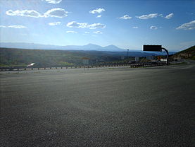
Looking into Colorado from Raton Pass | |
| Nearest city: | Trinidad, CO, Raton, NM |
| Raton Pass | |
|---|---|
| Elevation | 7,834 ft (2,388 m) |
| Traversed by | Interstate 25, US-85, US-87, Atchison, Topeka and Santa Fe Railway |
| Location | |
| Coordinates | 36°59′28″N 104°29′12″W / 36.9911344°N 104.4866544°WCoordinates: 36°59′28″N 104°29′12″W / 36.9911344°N 104.4866544°W |
The pass is located on the eastern side of the Sangre de Cristo Mountains between Trinidad, Colorado and Raton, New Mexico, approximately 100 miles (160 km) northeast of Santa Fe. The pass crosses the line of volcanic mesas that extends east from the Sangre de Cristo Mountains along the state line, and furnishes the most direct land route between the valley of the Arkansas River to the north and the upper valley of the Canadian River, leading to Santa Fe, to the south.


No comments:
Post a Comment